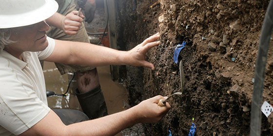
Researchers of all backgrounds come to Midpen preserves to conduct research in disciplines ranging from archaeology to zoology. This fall, geologists arrived at Monte Bello in search of evidence of past large earthquakes on the San Andreas Fault. Using “lidar” (light radar) technology, geologist Gordon Seitz of the California Geological Survey identified a location in Monte Bello with the specific conditions needed for his paleoseismic research project. At this specific spot, the San Francisco earthquake of 1906 ruptured the surface and shifted the earth approximately 10 feet. For their study, Seitz and his team dug two trenches near the Canyon Trail to expose earthquake-deformed sediment and are using radiocarbon dating to create an earthquake record of the last 500-1,000 years! This data will help researchers better understand past activity on the San Andreas Fault and better assess future seismic hazards.