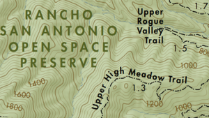
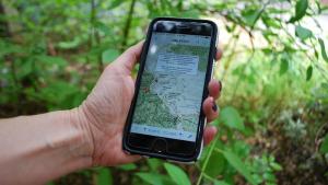
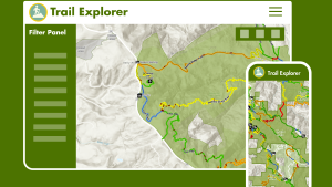
There are a variety of ways to find your way on our trails. Download a map from our preserve pages before leaving home, snap a photo of a signboard map at a trailhead or use a smartphone app to bring a digital map along on your adventures.
- Bear Creek Redwoods
- Coal Creek
- El Corte de Madera Creek
- El Sereno
- Foothills
- Fremont Older
- La Honda Creek
- Long Ridge
- Los Trancos
- Monte Bello
- Picchetti Ranch
- Pulgas Ridge
- Purisima Creek Redwoods
- Rancho San Antonio
- Ravenswood
- Russian Ridge
- Saratoga Gap
- Sierra Azul
- Skyline Ridge
- St. Joseph's Hill
- Stevens Creek Shoreline Nature Area
- Teague Hill
- Thornewood
- Windy Hill
Click here for instructions on printing a 17 x 22" map on 8.5 x 11" paper at home.
GEOPDF MAPS
All Midpen trail maps are in GeoPDF format, so you can download preserve maps and use them with an app on your mobile device. GeoPDFs have map coordinates embedded in them so that you can view your location on the map and even track your route. Because they work using your device’s GPS signal, you can continue to use them when you don’t have cell coverage.
Access these maps on your device using an one of the apps below or any GeoPDF reader.
Avenza Maps
Midpen maps can be downloaded for free from within the FREE Avenza Maps app or from the preserve pages on our website. Avenza Maps allows you to view maps offline, see your location on the map, plot placemarks and photo locations, and measure distance.
- The blue dot and crosshair shows your location.
- Drop placemarks and add photos at your location.
- Tap GPS button to view your current location. Tap placemark button to drop a pin.
- Use tools to record GPS tracks, find coordinates, add geotagged photos and more.
OuterSpatial
Access Midpen preserve maps and information in the palm of your hand with the FREE OuterSpatial app. OuterSpatial also provides access to maps and info from many other park agencies in our region and beyond.
A little bit of set up is necessary before you’re at the preserve to make sure you have the map you need while out on the trail, when cell coverage is often not available:
- Open the OuterSpatial app on your phone or tablet.
- Click Explore to find the preserve that you want to visit by using the search bar or clicking the area icon on the interactive map.
- Click on the selected preserve tile and scroll down to the Map Gallery section to open the Paper Map link.
- Zoom in on the map–once you can clearly read the trail names the paper map has loaded to your device.
When you’re at the preserve just re-open the map and click the arrow button (upper-right). The app will use GPS to center the map on your location, shown as a blue dot which works even when you do not have cell coverage or wifi.

Midpen provides various GIS data layers and interactive applications to help preserve visitors and tech-savvy map enthusiasts plan their outdoor activities and learn about Midpen preserves.