Saratoga to the Skyline Trail sign

Saratoga to the Skyline Trail

Saratoga to the Skyline Trail sign

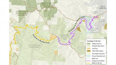
Midpeninsula Regional Open Space District supports the creation of a regional network of trails that connects communities to open space both within the preserves that the agency manages and throughout the district itself. As a result, Midpen engages in partnership projects, including the Saratoga to the Skyline Trail project, as envisioned by the City of Saratoga. Linking the city's Quarry Park with Santa Clara County's Sanborn County Park, the 9.7-mile trail opened to the public in November 2020.

Midpen and the City of Saratoga's partnership began in 2011, when Midpen financially supported the city's purchase of the 64-acre property that became Quarry Park. When planning for the Saratoga-to-the-Skyline Trail project began in 2017, Midpen provided technical support and committed $1.365 million in funding towards engineering design, environmental review and construction.
Image
Map of Saratoga to the Skyline Trail
For illustrative purposes only, map does not show allowed trail uses
Image
Public Access, Education, and Outreach
Public Access
Image
illustration of a bird in flight next to the letters MAA
Measure AA

Plan Your Visit

The Saratoga to the Skyline Trail is operated and managed by the City of Saratoga and Santa Clara County Parks. Please refer to the City of Saratoga’s Quarry Park and the Saratoga to the Skyline Trail web page and Santa Clara County Parks Sanborn County Park’s web page for official trail maps and information on allowed uses. 

Saratoga-to-the-Skyline Trail allows hiking, equestrians and dogs on leash; no bikes except on the Skyline Trail segment that parallels Hwy 35 in Sanborn County Park. Whether you are looking for a day hike or want to backpack from Saratoga to the sea, here are links for more information:  

Image
Funded by Measure AA 2014 Open Space Bond

Measure AA

This project was funded by Measure AA general obligation bonds, approved by voters in 2014.